1571 result(s)
123...158
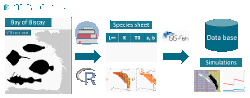
As part of the MACCO research project (https://www.macco.fr), we developped an ISIS-Fish database (Mahevas et al 2004, Pelletier et al 2009, https://isis-fish.org) describing the mixed demersal fishery in the Bay of Biscay. For this application, the spatial extent of the fishery is the Bay of Biscay, defined here by ICES divisions 8a, 8b and 8d and the resolution chosen is 1/16 ICES statistical rectangle. The period modeled is 2015-2022, with a m [...]
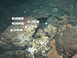
This dataset contains temperature data acquired between July 2023 and June 2024 using 5 thermocrons i-buttons © installed along chains nearby the SMOOVE camera connected the SeaMoN East frame. Data was acquired every hour. The array is not connected to an energy node. They are associated with the SMOOVE camera which is part of the SeaMoN East ecological monitoring node. Location : N 37°17.334, W 32°16.534, 1692 m
In the context of the MACCO project (https://www.macco.fr/), we have developed an ISIS-Fish database with the objective of describing the spatial and monthly life cycle of 7 fish species of commercial interest in the mixed demersal fishery in the Bay of Biscay. In the case of megrim, cuckoo skate, thornback skate, anglerfish and sole, the population dynamics have been described in detail, both by age class and by global model. In addition, the di [...]
This IGA-HP Gravelines dataset includes long-term time series on marine phytoplankton, zooplankton, and hydrological data from 1978 onward at the coastal station named “canal d’Amenée” (in French) near the Gravelines Nuclear Power Plant located in the southern bight of the North Sea, near the Dover Strait (eastern English Channel). Phytoplankton data essentially cover microscopic taxonomic identifications and counts (cells.l-1), and pigment conce [...]
Three saltmarshes, Aiguillon, Brouage, Fier d'Ars, located in the Pertuis-Charentais Sea along the south-west coast of France, were studied to evaluate their sediment and mass accumulation rates (SAR; MAR) based on 210Pb and 137Cs profiles in sediments. Coastal saltmarshes play indeed an essential role in providing services such as coastal protection and supporting biodiversity. Saltmarshes are also critical environments for the accumulation of s [...]
This table contains raw data supporting the findings from publication "Nascent water waves induced by the impulsive motion of a solid wall" by W. Sarlin, Z. Niu, A. Sauret, P. Gondret & C. Morize Each line corresponds to an experiment, with the different columns indicating respectively: o the regime attributed to the wave* o the total stroke of the piston L in meters o the maximum velocity U reached by the piston in meters per second o the init [...]
RedAnDA TS, UnivarS and UnivarT are the different versions of RedAnDA, applied respectively to temperature-salinity (coupled), salinity and temperature monthly reconstructions. The coupled approach uses bivariate 3D EOFs with density-weighting, while the univariate version use simple 3D EOFs. In RedAnDA, the system state is described by the reduced set of EOFs, as in reduced-space interpolation. Additionnaly, it uses an Ensemble Kalman Smoother s [...]
This dataset consists of a quantitative imaging dataset of ZooScan-imaged mesoplankton and microplastics, collected with the Manta net (333 µm mesh size) aboard the schooner Tara during the Tara Pacific Expedition (2016-2018). Samples were collected at the surface across the Pacific Oceans from open-ocean stations (32 samples, open-ocean label: [i00_oa###]), with 28 samples located on the Great Pacific Garbage Patch, and from stations in coastal [...]
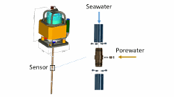
The piezometer is designed to measure in-situ pore pressure relative to the hydrostatic pressure and temperature. For this dataset, in-situ excess pore pressure and temperature measurements were made using cable-deployed piezometers equipped with a sediment piercing lance of 60 mm diameter carrying differential pore pressure (pore pressure in excess of hydrostatic pressure or fluid excess pore pressure) and temperature sensors, ballasted with lea [...]
The gravitational pump plays a significant role in the carbon cycle by exporting sinking organic carbon from the surface to the deep ocean. The deep sediment time-series traps provide unique observations of this sequestered carbon fluxes. However, the sinking particles trapped are sensitive to physical short-term spatial and temporal fluctuations, which present a challenge in establishing a connection with their surface origin. In this study, we [...]