Copy this text
ECOSCOPA network : National monitoring network of mortality and growth rates of the sentinel oyster Crassostrea gigas
The network was initiated by IFREMER from 1993 to 2009 (under the acronym REMORA) to study the rearing performance of the Pacific oyster Crassostrea gigas at a national scale. To do so, the network monitored annually the mortality and growth of standardized batches of 18-month-old oysters. Starting in 1995, the monitoring of the rearing performance of 6-month-old oyster spat was integrated into this network. These sentinel batches were distributed simultaneously each year on 43 sites and were monitored quarterly. These sites were distributed over the main French oyster farming areas and allowed a national coverage of the multiannual evolution of oyster farming performances. Most of the sites were located on the foreshore at comparable levels of immersion. Field studies were carried out by the "Laboratoires Environnement Ressources" (LER) for the sites included in their geographical area of investigation.
Following the increase in spat mortality in 2008, the network evolved in 2009 (under the acronym RESCO). From this date, the network selected 13 sites among the 43 sites previously monitored in order to increase the frequency of visits (twice a month) and the number of sentinel batches. More precisely, sentinel batches of oysters corresponding to different origins (wild or hatchery, diploid or triploid) and to two rearing age classes (spat or 18-month-old adults) were selected. The monitoring of environmental variables (temperature, salinity) associated with the 13 sites was also implemented. The actions of the network have thus contributed to disentangle the biotic and abiotic parameters involved in mortality phenomena, taking into account the different compartments (environment / host / infectious agents) likely to interact with the evolution of oyster rearing performance.
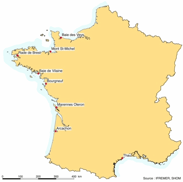
Finally, since 2015, the network has merged the RESCO and VELYGER networks to adopt the acronym ECOSCOPA. The general objective of this current network is to analyze the causes of spatio-temporal variability of the main life traits (Larval stage - Recruitment - Reproduction - Growth - Survival - Cytogenetic abnormalities) of the cupped oyster in France and to follow their evolution on the long term in the context of climate change. To do this, the network proposes a regular spatio-temporal monitoring of the major proxies of the life cycle of the oyster, organized in three major thematic groups: (1) proxies related to growth, physiological tolerance and survival of experimental sentinel populations over 3 age classes: (2) proxies related to reproduction, larval phase and recruitment of the species throughout its natural range in France, and: (3) proxies related to environmental parameters essential to the species (weather conditions, temperature, salinity, pH, turbidity, chlorophyll a and phytoplankton) at daily or sub-hourly frequencies. Working in a geographical network associating several laboratories, ECOSCOPA provide these monitoring within 8 sites selected among the previous ones to ensure the continuity of the data acquisition. Today, these 8 sites are considered as ecosystems of common interest, contrasted, namely :
- The Thau lagoon
- The Arcachon basin
- The Marennes Oléron basin
- The Bourgneuf Bay
- The bay of Vilaine
- The bay of Brest
- The bay of Mont Saint Michel
- The bay of Veys
The ECOSCOPA network is therefore one of the relevant monitoring tools on a national scale, allowing to objectively measure through different proxies the general state of health of cultivated and wild oyster populations, and this for the different sensitive phases of their life cycle. This network aims at allowing a better evaluation, on the long term, of the biological risks incurred by the sector but also by the ecosystems, in particular under the increasing constraint of climatic and anthropic changes.

Figure : Sites monitored by the ECOSCOPA network
Disciplines
Biological oceanography
Location
43.21396N, 43.21396S, 3.33393E, 3.33393W
48.344734N, 48.344734S, -4.362341E, -4.362341W
46.576565N, 46.576565S, -2.052075E, -2.052075W
46.570924N, 46.570924S, -2.078605E, -2.078605W
47.353075N, 47.353075S, -2.531481E, -2.531481W
47.015614N, 47.015614S, -2.018047E, -2.018047W
49.34547N, 49.34547S, -1.16912E, -1.16912W
49.23349N, 49.23349S, -1.05986E, -1.05986W
49.03509N, 49.03509S, -1.37277E, -1.37277W
48.403073N, 48.403073S, -3.559502E, -3.559502W
47.322896N, 47.322896S, -3.055808E, -3.055808W
49.12948N, 49.12948S, -1.38889E, -1.38889W
49.05585N, 49.05585S, -1.37297E, -1.37297W
43.227478N, 43.227478S, 3.342648E, 3.342648W
47.33773N, 47.33773S, -2.55914E, -2.55914W
49.255N, 49.255S, -1.10617E, -1.10617W
49.21017N, 49.21017S, -0.33755E, -0.33755W
48.396588N, 48.396588S, -1.504812E, -1.504812W
49.33347N, 49.33347S, -1.17565E, -1.17565W
44.39977N, 44.39977S, -1.08387E, -1.08387W
44.34795N, 44.34795S, -1.14326E, -1.14326W
48.176063N, 48.176063S, -4.329669E, -4.329669W
49.23707N, 49.23707S, -1.045E, -1.045W
45.521125N, 45.521125S, -1.103384E, -1.103384W
44.38667N, 44.38667S, -1.14365E, -1.14365W
46.135042N, 46.135042S, -1.242435E, -1.242435W
49.35496N, 49.35496S, -1.15177E, -1.15177W
43.23817N, 43.23817S, 3.351072E, 3.351072W
45.480286N, 45.480286S, -1.10882E, -1.10882W
43.266513N, 43.266513S, 3.388655E, 3.388655W
48.460415N, 48.460415S, -2.589493E, -2.589493W
46.002936N, 46.002936S, -1.079349E, -1.079349W
47.339632N, 47.339632S, -2.473715E, -2.473715W
45.546971N, 45.546971S, -1.10808E, -1.10808W
47.250572N, 47.250572S, -2.271819E, -2.271819W
43.26058N, 43.26058S, 3.399048E, 3.399048W
47.32847N, 47.32847S, -3.0315E, -3.0315W
47.306065N, 47.306065S, -2.388803E, -2.388803W
46.119237N, 46.119237S, -1.289935E, -1.289935W
47.419897N, 47.419897S, -3.102478E, -3.102478W
47.337396N, 47.337396S, -3.071642E, -3.071642W
48.397407N, 48.397407S, -3.537001E, -3.537001W
47.036953N, 47.036953S, -2.013297E, -2.013297W

