(2019). I-AMICA coastal hydrological surveys in the eastern Tyrrhenian Sea. SEANOE. https://doi.org/10.17882/70324
Copy this text
Hydrological data have been collected during 7 oceanographic surveys, named I-AMICA, jointly organized between June 2012 and October 2014 (table 1) by the Italian National Research Council (CNR), the Istituto Superiore per la Protezione e la Ricerca Ambientale (ISPRA) and the Istituto Nazionale di Geofisica e Vulcanologia (INGV), adjacent to the shelf area of the Volturno River mouth (Gulf of Gaeta - central part of the Tyrrhenian Sea, western Mediterranean basin) between 40.85-41.10 °N in latitude and 13.8-14 °E in longitude.
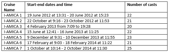
Table 1
I-AMICA project was planned to increase the observational capacity of the monitoring of marine coastal ecosystems, particularly vulnerable in the sensitive Mediterranean area and strictly connected to the natural and anthropic continental system. For this reason research activities were mainly focused on the neritic environment adjacent to the continental shelf in front of the Volturno river mouth with a bathymetric range of 5-50 m. Advanced knowledge on the dynamics in time of marine coastal ecosystems, in relation to the physical, chemical and biological processes that characterize their habitat, were acquired while new methods of integrated monitoring, in relation to the specific characteristics of the study area, were tested. Particular attention was given to the identification of bio-indicators in water column and sediment at sea floor. During each survey 20-25 hydrological casts along five transects perpendicular to the coast have been collected at a depth range of 9-50 m. A quasi-regular grid, of about 2 km in longitude and 3 km in latitude, represents the classic strategy for a synoptic ocean sampling. Data of pressure, conductivity, temperature, dissolved oxygen, pH, beam transmission and attenuation, Chlorophyll-a fluorescence (Chl-a) were acquired by sensors installed on a SBE11 plus (Firmware version 5.0) multiparametric probe by Sea-Bird Inc.. The beam transmission and attenuation was used to estimate the "turbidity" or to measure the attenuation of the infrared beam from the emitter to the receiver, as a result it gives % and 1/m, but just the % was used. The calibration of sensors was made in 2013 for pressure, conductivity, temperature, oxygen sensors at SeaBird Inc. while in 2011 for pH, transmissometer and fluorometer. The vertical profiles of all parameters were obtained by sampling the signals at 24 Hz, with the CTD/rosette going down at a speed of 1 m/s. The probe was used on board the R/V Astrea of ISPRA, a vessel with a length overall of 24 m, a breadth extreme of 6 m and a draught of 3 m, that can use any type of instrumentation and perform oceanographic research (biological, chemical and physical) in coastal and high seas areas. Each survey was performed in 1-2 days and in good weather and sea conditions. A quality check control on acquired CTD data has been done in order to remove possible spikes along the profiles. The raw data collected have been converted and processed using the SBE Data Processing software (version 7.26) while the Ocean Data View software [Schlitzer R. (2019). Ocean Data View. https://odv.awi.de/] was used for the representation of the sections of the sampled transects on paper.
The data set is provided per cruise as ODV Spreadsheet files in TXT format where missing data values are set to -1.e10.
MetaVariable
Cruise name
Station
Type of acquisition (here C)
Date in mon/day/yr and Time in hh:mm
Longitude [degrees_east]
Latitude [degrees_north]
Bot. Depth [m]
DataVariable
Pressure, Digiquartz with TC [db]
Temperature [deg C];
Conductivity [mS/cm]
Oxygen, SBE43 [ml/l]
Fluorescence, Turner Cyclops fluorometer. No data in I-AMICA7.
Beam transmission (%) and attenuation (1/m), Transmissometer, WET Labs C-Star
Physical oceanography, Chemical oceanography, Environment
hydrological data, river mouth, Gaeta Gulf, CTD profiles, Tyrrhenian Sea, numerical model, water masses
41.265N, 40.7S, 13.5E, 14.08W
40.01N, 40.01S, 13.76E, 14W
In specific, used CTD sensors had the following characteristics:
• pressure: a Digiquarz with TC pressure transducer was used. The transducer had a resolution of 0.01 ppm, oscillator frequency 34 KHz - 38KHz and temperature range 0 °C - 125 °C;
• temperature: a SBE-3/F thermometer with response time of 70 ms, temperature range -5 ° - + 35 °, accuracy about 0.004 ° C per year, resolution 0.0003 ° C;
• conductivity: a SBE-4 sensor with a range of 0.0 - 7 S/m, resolution 3 x 10⁻⁴ S/m, accuracy about 0.0003 S/m per month and response time of 0.085 sec with pump or 0.17 sec without pump;
• dissolved oxygen: a SBE-43 polarographic membrane sensor for pumped CTD applications with titanium (7000 m) housing was used with a range of 120% of surface saturation in all natural waters, accuracy of ±2% of saturation;
• fluorescence: a Turner Cyclops fluorometer. It is not present in the data of I-AMICA7;
• beam transmission and attenuation: transmissometer, WET Labs C-Star [%], path length 0.10 (m), Spectral Bandwidth 20nm, Wavelength 530 nm, Depth rating 600m, Sample Rate to 8 Hz
| File | Size | Format | Processing | Access | |
|---|---|---|---|---|---|
I-AMICA1 - ODV Spreadsheet in TXT and maps in JPEG | 306 Ko | TEXT | Quality controlled data | ||
I-AMICA2 - ODV Spreadsheet in TXT and maps in JPEG | 304 Ko | TEXT | Quality controlled data | ||
I-AMICA3 - ODV Spreadsheet in TXT and maps in JPEG | 293 Ko | TEXT | Quality controlled data | ||
I-AMICA4 - ODV Spreadsheet in TXT and maps in JPEG | 297 Ko | TEXT | Quality controlled data | ||
I-AMICA5 - ODV Spreadsheet in TXT and maps in JPEG | 317 Ko | TEXT | Quality controlled data | ||
I-AMICA6 - ODV Spreadsheet in TXT and maps in JPEG | 301 Ko | TEXT | Quality controlled data | ||
I-AMICA7 - ODV Spreadsheet in TXT and maps in JPEG | 316 Ko | TEXT | Quality controlled data |
Copy this text
