Hydrological profiles in the Mediterranean Sea (2002 - 2006)
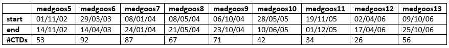
Hydrological data have been collected during 9 oceanographic cruises, named medgoos, organized in the whole Mediterranean basin between November 2002 and October 2006 (table 1) by the Italian National Research Council (CNR). The three medgoos cruises numbered from 5 to 7 are already part of another database (Ribotti et al., 2019) just covering the Sardinia Channel and Sea. Here they are complete.
Like in the previous medgoos cruises (Ribotti et al., 2019), also for these the 61,30 meters long R/V Urania of CNR was used. Data of conductivity, temperature, dissolved oxygen (DO) and Chlorophyll-a fluorescence (Chl-a, apart during the medgoos11 cruise) were acquired by sensors installed on a SBE911 plus CTD probe (Sea-Bird Inc.). It was equipped with a 24 Niskin bottle rosette for water column samples collection. The vertical profiles of all parameters were obtained by sampling the signals at 24 Hz, with the CTD/rosette going down at a speed of 1 m/s. On board the CTD data were quality checked and processed by Seasoft software, and the coarse errors corrected. Then the salinity was checked against the on-board analyses of water samples by a Guildline-Autosal salinometer. The same for DO data checked against Winkler titration analyses. Chl-a data were not calibrated, so they are reported as Relative Fluorescence Unit. During cruises from medgoos5 to 7 acquired temperature data were checked at defined depths against inverted thermometers installed in correspondence of the Niskin bottles number 1, 3, 5, 7 of the rosette sampler. Pre-cruise and post-cruise calibrations of the sensors were performed at the SACLANT Center (now NATO-CMRE) of La Spezia (Italy). Redundant sensors were often used for both temperature and salinity measurements. The vessel was positioned using an integrated navigation system consisting of two DGPS antennas managed by Andrews Hydrographics software installed on HP 386, 33 MHz PCs. The data set is provided per cruise as Ocean Data View (ODV, Schlitzer R., 2019) Spreadsheet files in TXT format where missing data values are set to -1.e10.
MetaVariable
Cruise name
Station
Type of acquisition (here C)
Date in mon/day/yr and Time in hh:mm
Longitude [degrees_east]
Latitude [degrees_north]
Bot. Depth [m]
DataVariable (not always in the following order)
Pressure, Digiquartz [db]
Temperature [deg C]; ITS-68, also ITS-90 just in medgoos5
Conductivity [mS/cm]
Oxygen, SBE43 [ml/l]
Fluorescence, Seatech in medgoos5, 6, 7, 8, 9, 10
Disciplines
Physical oceanography
Keywords
hydrological data, Gibraltar Strait, CTD profiles, Mediterranean Sea, water masses
Location
47.440764N, 25.777197S, 36.85876E, -12.35999W
Devices
In specific, used CTD sensors had the following characteristics:
pressure: a Digiquarz 4000 pressure transducer was used. The transducer had a resolution of 0.01 ppm, oscillator frequency 34 KHz - 38KHz and temperature range 0 °C - 125 °C;
temperature: a SBE-3/F thermometer with response time of 70 ms, temperature range -5 ° - + 35 °, accuracy about 0.004 ° C per year, resolution 0.0003 ° C;
conductivity: a SBE-4 sensor with a range of 0.0 - 7 S/m, resolution 3 x 10⁻⁴ S/m, accuracy about 0.0003 S/m per month and response time of 0.085 sec with pump or 0.17 sec without pump;
dissolved oxygen: a SBE-13 Beckman/YSI sensor with a range of 0 - 15 ml/l, accuracy of 0.1 ml/l, resolution 4.3 μM and response time 2 sec at a temperature of 25 °C during cruises medgoos1, 2, 3, 4. During cruises medgoos5, 6, 7 a SBE-43 polarographic membrane sensor for pumped CTD applications with titanium (7000 m) housing was used with a range of 120% of surface saturation in all natural waters, accuracy of ±2% of saturation
fluorescence: a Sea Tech Inc. fluorometer with energy emitted by the flash lamp of 0.25 J for flash, temperature range 0 ° - 25 °C, resolution 0.15 mg/l. Since medgoos12 the Chelsea Aqua 3 fluorometer was used. It is not present in the data of medgoos11 due to sensor malfunction.
Data
File
Size
Format
Processing
Access
Compressed dataset with map and ocean data from the cruise medgoos5
Ribotti Alberto, Perilli Angelo, Sorgente Roberto, Borghini Mireno (2019). Hydrological profiles in the Mediterranean Sea (2002 - 2006). SEANOE. https://doi.org/10.17882/70340
In addition to properly cite this dataset, it would be appreciated that the following work(s) be cited too, when using this dataset in a publication :
Ribotti Alberto, Sorgente Roberto, Pessini Federica, Cucco Andrea, Quattrocchi Giovanni, Borghini Mireno (2022). Twenty-one years of hydrological data acquisition in the Mediterranean Sea: quality, availability, and research. Earth System Science Data, 14 (9). https://doi.org/10.5194/essd-14-4187-2022
Copy this text
Related documents
Ribotti Alberto, Sorgente Roberto, Pessini Federica, Cucco Andrea, Quattrocchi Giovanni, Borghini Mireno (2022). Twenty-one years of hydrological data acquisition in the Mediterranean Sea: quality, availability, and research. Earth System Science Data, 14 (9). https://doi.org/10.5194/essd-14-4187-2022
Pessini Federica, Cotroneo Yuri, Olita Antonio, Sorgente Roberto, Ribotti Alberto, Jendersie Stefan, Perilli Angelo (2020). Life history of an anticyclonic eddy in the Algerian basin from altimetry data, tracking algorithm and in situ observations.. Journal of Marine Systems, 103346-. https://doi.org/10.1016/j.jmarsys.2020.103346
Ribotti Alberto, Sorgente Roberto, Borghini Mireno (2020). Quality assurance and control on hydrological data off western Sardinia (2000–2004), western Mediterranean. Earth System Science Data, 12 (2), 1287-1294. https://doi.org/10.5194/essd-12-1287-2020
Schroeder K., Ribotti A., Borghini M., Sorgente R., Perilli A., Gasparini G. P. (2008). An extensive western Mediterranean deep water renewal between 2004 and 2006. Geophysical Research Letters, 35 (18), -. https://doi.org/10.1029/2008GL035146