Gridded bathymetric data along the ultraslow spreading Southwest Indian Ridge between the Gallieni TF and the Rodrigues triple Junction
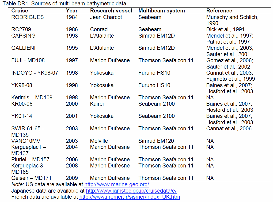
Six large grids were obtained by merging multibeam bathymetric data from several international cruises along the Southwest Indian Ridge from the Gallieni Transform Fault (54°E) to the Rodrigues Triple Junction (70°E). The spatial resolution is about 150 m. This dataset was used in several scientific papers.
Disciplines
Marine geology
Keywords
Multibeam bathymetric data, grids, ultraslow spreading, Southwest Indian Ridge
Sauter Daniel, Cannat Mathilde (2022). Gridded bathymetric data along the ultraslow spreading Southwest Indian Ridge between the Gallieni TF and the Rodrigues triple Junction. SEANOE. https://doi.org/10.17882/90631
In addition to properly cite this dataset, it would be appreciated that the following work(s) be cited too, when using this dataset in a publication :
Sauter Daniel, Sloan Heather, Cannat Mathilde, Goff John, Patriat Philippe, Schaming Marc, Roest Walter (2011). From slow to ultra-slow: How does spreading rate affect seafloor roughness and crustal thickness?. GEOLOGY. 39 (10). 911-914. https://doi.org/10.1130/G32028.1
Sauter D, Carton H, Mendel V, Munschy M, Rommevaux-Jestin C, Schott JJ, Whitechurch H (2004). Ridge segmentation and the magnetic structure of the Southwest Indian Ridge (at 50 degrees 30 ' E, 55 degrees 30 ' E and 66 degrees 20 ' E): Implications for magmatic processes at ultraslow-spreading centers. Geochemistry Geophysics Geosystems. 5 (5). 1-25. https://doi.org/10.1029/2003GC000581
Mendel V, Sauter D, Rommevaux-Jestin C, Patriat P, Lefebvre F, Parson LM (2003). Magmato-tectonic cyclicity at the ultra-slow spreading Southwest Indian Ridge: Evidence from variations of axial volcanic ridge morphology and abyssal hills pattern. Geochemistry Geophysics Geosystems. 4 (5). 1-23. https://doi.org/10.1029/2002GC000417