1438 result(s)
123...144
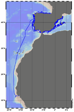
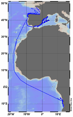
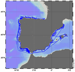
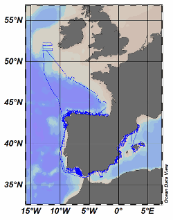
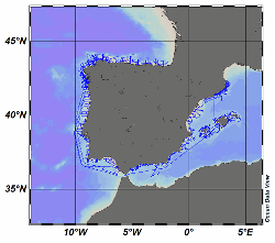
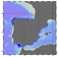
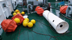
The R/V Miguel Oliver was built in 2007 for scientific fisheries assessment and oceanographic research purposes. Owned by the Spanish General Secretariat of Fisheries, it mainly operates around the Iberian Peninsula and Canary Islands waters. Equipped with an automatic weather station, collected data are daily sent to the Spanish Institute of Oceanography (IEO) Data Center / National Oceanographic Data Center (NODC) for delayed-mode quality contr [...]
The R/V Miguel Oliver was built in 2007 for scientific fisheries assessment and oceanographic research purposes. Owned by the Spanish General Secretariat of Fisheries, it mainly operates around the Iberian Peninsula and Canary Islands waters. Equipped with an automatic weather station, collected data are daily sent to the Spanish Institute of Oceanography (IEO) Data Center / National Oceanographic Data Center (NODC) for delayed-mode quality contr [...]
The R/V Miguel Oliver was built in 2007 for scientific fisheries assessment and oceanographic research purposes. Owned by the Spanish General Secretariat of Fisheries, it mainly operates around the Iberian Peninsula and Canary Islands waters. Equipped with an automatic weather station, collected data are daily sent to the Spanish Institute of Oceanography (IEO) Data Center / National Oceanographic Data Center (NODC) for delayed-mode quality contr [...]
The R/V Miguel Oliver was built in 2007 for scientific fisheries assessment and oceanographic research purposes. Owned by the Spanish General Secretariat of Fisheries, it mainly operates around the Iberian Peninsula and Canary Islands waters. Equipped with an automatic weather station, collected data are daily sent to the Spanish Institute of Oceanography (IEO) Data Center / National Oceanographic Data Center (NODC) for delayed-mode quality contr [...]
The R/V Miguel Oliver was built in 2007 for scientific fisheries assessment and oceanographic research purposes. Owned by the Spanish General Secretariat of Fisheries, it mainly operates around the Iberian Peninsula and Canary Islands waters. Equipped with an automatic weather station, collected data are daily sent to the Spanish Institute of Oceanography (IEO) Data Center / National Oceanographic Data Center (NODC) for delayed-mode quality contr [...]
The R/V Miguel Oliver was built in 2007 for scientific fisheries assessment and oceanographic research purposes. Owned by the Spanish General Secretariat of Fisheries, it mainly operates around the Iberian Peninsula and Canary Islands waters. Equipped with an automatic weather station, collected data are daily sent to the Spanish Institute of Oceanography (IEO) Data Center / National Oceanographic Data Center (NODC) for delayed-mode quality contr [...]
The R/V Miguel Oliver was built in 2007 for scientific fisheries assessment and oceanographic research purposes. Owned by the Spanish General Secretariat of Fisheries, it mainly operates around the Iberian Peninsula and Canary Islands waters. Equipped with an automatic weather station, collected data are daily sent to the Spanish Institute of Oceanography (IEO) Data Center / National Oceanographic Data Center (NODC) for delayed-mode quality contr [...]
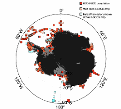
This mooring timeseries compilation contains temperature, salinity, current velocity measured from a wide range of marine instrument in the Southern Ocean (90°S-60°S) since 1975. It provides with an opportunity to investigate the broad scale climatology of the Southern Ocean shelf dynamics and shelf connecitivity of dense shelf water and freshwater propogation, and facilitate the timeseries analysis across various timescales.
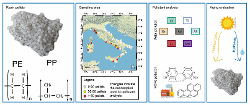
During 2019, the LEGAMBIENTE conducted a marine litter survey collecting 2270 pellets from 73 Italian beaches along the peninsula within a citizen science campaign. The geographical regions sampled were: Abruzzo, Calabria, Campania, Emilia Romagna, Lazio, Liguria, Marche, Molise, Puglia, Sardegna, Sicilia, Toscana e Veneto. The sampling procedure consists in collecting items considering the part of the beach that undergo the dynamics of the unde [...]
In 2013, Argentina declared its first open-sea Marine Protected Area (MPA) on the plateau of the Burdwood Bank, under the name Namuncurá/Burdwood Bank. Initially delimited by the 200-m isobath and including only the gently sloping plateau of the bank, the MPA was subsequently expanded to the southern steep slope in 2018 (Namuncurá/Burdwood Bank II), reaching a total protected area of 60336 km2. Encouraged by the need to inform decision makers an [...]