1433 result(s)
123...144
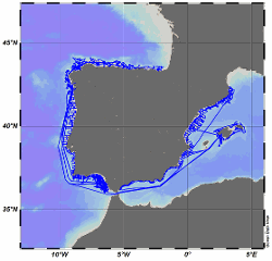
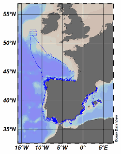
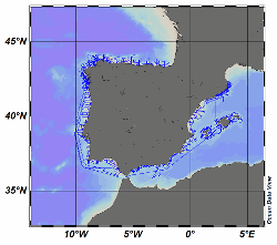
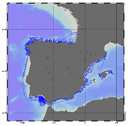
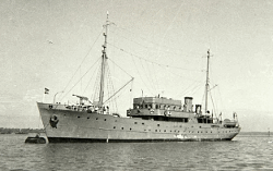
The R/V Miguel Oliver was built in 2007 for scientific fisheries assessment and oceanographic research purposes. Owned by the Spanish General Secretariat of Fisheries, it mainly operates around the Iberian Peninsula and Canary Islands waters. Equipped with an automatic weather station, collected data are daily sent to the Spanish Institute of Oceanography (IEO) Data Center / National Oceanographic Data Center (NODC) for delayed-mode quality contr [...]
The R/V Miguel Oliver was built in 2007 for scientific fisheries assessment and oceanographic research purposes. Owned by the Spanish General Secretariat of Fisheries, it mainly operates around the Iberian Peninsula and Canary Islands waters. Equipped with an automatic weather station, collected data are daily sent to the Spanish Institute of Oceanography (IEO) Data Center / National Oceanographic Data Center (NODC) for delayed-mode quality contr [...]
The R/V Miguel Oliver was built in 2007 for scientific fisheries assessment and oceanographic research purposes. Owned by the Spanish General Secretariat of Fisheries, it mainly operates around the Iberian Peninsula and Canary Islands waters. Equipped with an automatic weather station, collected data are daily sent to the Spanish Institute of Oceanography (IEO) Data Center / National Oceanographic Data Center (NODC) for delayed-mode quality contr [...]
The R/V Miguel Oliver was built in 2007 for scientific fisheries assessment and oceanographic research purposes. Owned by the Spanish General Secretariat of Fisheries, it mainly operates around the Iberian Peninsula and Canary Islands waters. Equipped with an automatic weather station, collected data are daily sent to the Spanish Institute of Oceanography (IEO) Data Center / National Oceanographic Data Center (NODC) for delayed-mode quality contr [...]
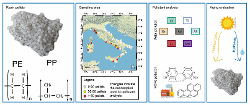
During 2019, the LEGAMBIENTE conducted a marine litter survey collecting 2270 pellets from 73 Italian beaches along the peninsula within a citizen science campaign. The geographical regions sampled were: Abruzzo, Calabria, Campania, Emilia Romagna, Lazio, Liguria, Marche, Molise, Puglia, Sardegna, Sicilia, Toscana e Veneto. The sampling procedure consists in collecting items considering the part of the beach that undergo the dynamics of the unde [...]
In 2013, Argentina declared its first open-sea Marine Protected Area (MPA) on the plateau of the Burdwood Bank, under the name Namuncurá/Burdwood Bank. Initially delimited by the 200-m isobath and including only the gently sloping plateau of the bank, the MPA was subsequently expanded to the southern steep slope in 2018 (Namuncurá/Burdwood Bank II), reaching a total protected area of 60336 km2. Encouraged by the need to inform decision makers an [...]
These data were collected as part of the Boundary Layer Turbulence and Abyssal Recipes (BLT Recipes) Experiment which focused on near-bottom processes within a continental slope canyon on the eastern side of the Rockall Trough, off Ireland. This specific dataset contains a bathymetry product based on data collected with the shipboard multibeam on RRS Discovery during cruises in 2021 and 2022.
COAST-HF (Coastal OceAn observing SysTem - High Frequency) is a national observation service belonging to the ILICO Research Infrastructure. This network, accredited by the CNRS, aims to federate and coordinate a set of fixed instrumented platforms for high-frequency in situ measurements of key coastal water parameters throughout the French coastline. The aim is to analyze and understand currents, hydrological structure, exchanges and the evoluti [...]
Climate change is projected to increase the frequency and intensity of marine heatwaves, potentially having drastic consequences on coastal environments. To assess how heatwaves of various intensities affect plankton communities in the Baltic Sea, an indoor mesocosm experiment was conducted with natural plankton communities sampled in the water column of the Gulf of Finland (N 59.91687, E 25.03022, max 82 m). Mesocosms were subjected to four diff [...]
This dataset contains an inventory of the benthic fauna of the Tunisian coasts by bottom trawling and dredging. The objectives are not known. We assume that this is an exploratory seabed trawling survey to assess the fishing possibilities in the region with this gear. We know that the inventory was written by Jacques Ancellin (director of the Boulogne-sur-Mer laboratory after the Second World War and he joined the OSTPM in 1942). Only species pre [...]